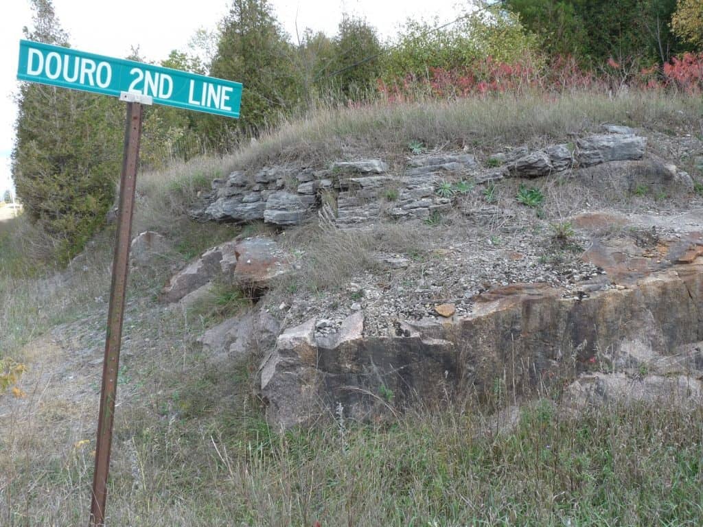
When you drive up County Road 23 into Buckhorn, you have probably noticed the abrupt transition in the bedrock. As you approach the town from the south, layers of limestone line both sides of the road. However, as you exit on the north side, the rock changes abruptly to expanses of beautiful pink granite. The same transition can be seen as you drive into Burleigh Falls on Highway 28. And, if you head up County Road 6 and stop at the Second Line of Dummer-Douro, you can actually see limestone sitting on top of granite, almost like a hamburger bun atop a meat patty. Moving further east, you will see the same changes in roadside bedrock along Highway 7, especially between Marmora and Kaladar.
This transition zone where the limestone bedrock of the St. Lawrence Lowlands meets the igneous and metamorphic rock of the Canadian Shield is known as “The Land Between”. But why even give it a name? Well, ecologists have discovered that this area of transition has features that are entirely its own. The landscape is less rugged than further north, but not as flat or fertile as the south. The land rises and falls in patterns of low to high and wet to dry. It forms a mosaic of interconnected environments. An abundance of rivers, small lakes and wetlands are nestled between open granite ridges and rock barrens. In other areas, mixed woodlands, abundant conifers and even limestone plains (alvars) can be found. There are fewer roads and farmlands are rare.
Location
The Land Between extends from the Frontenac Arch in the east (the area of granite rock you pass through on the 401 between Kingston and Belleville) to Georgian Bay and Southern Parry Sound in the west. Over 240 km in length and averaging 35 km wide, it spans nine counties and includes much of “Cottage Country”, namely the Kawarthas, Haliburton, Land O’ Lakes and Muskoka. Looking at a satellite image of Central Ontario, you can immediately see the region as band of green that stands out in stark contrast to the much more open, relatively treeless expanse to the south.
Species
The Land Between is a meeting ground where southern species more typical of the St. Lawrence Lowlands rub shoulders with plants and animals that are common on the Canadian Shield. It represents the northern limit for species such as White Oak, Butternut, Woodchuck, Cottontail Rabbit, Green Heron, American Crow and Blanding’s Turtle. At the same time, the region is generally the southern limit for Jack Pine, Moose, Black Bear, American Martin, Common Loon, Gray Jay, Dark-eyed Junco and Mink Frog.
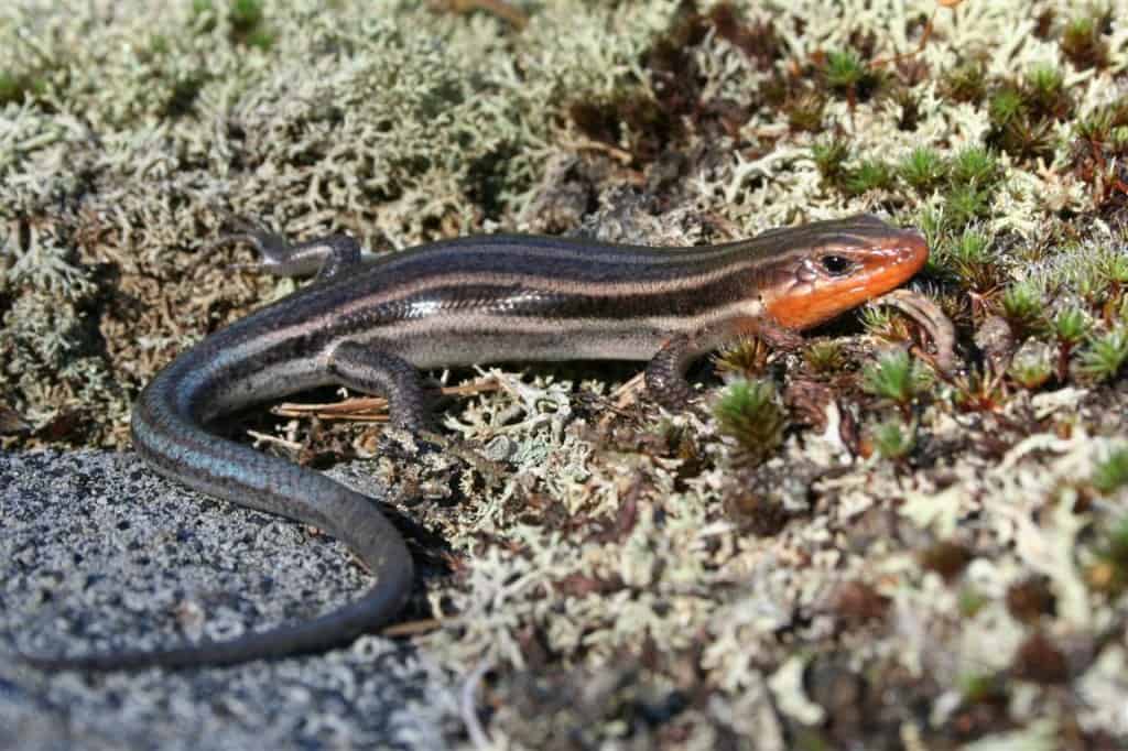
Some birds are almost entirely dependent on this landscape. Among these are Golden-winged and, in some areas, Prairie Warblers. At least 26 bird species have their highest population densities in The Land Between. These include Ruby-throated Hummingbirds, Bobolinks, Eastern Towhees, Upland Sandpipers, Whip-poor-wills, Common Nighthawks and Pileated Woodpeckers. The area is also home to Ontario’s largest populations of uncommon turtles (e.g., Blanding’s), snakes (e.g., Eastern Hognose) and Ontario’s only lizard, the Five-lined Skink. All of these are species at risk.
As for mammals, 48 of the 80 plus species occurring in Ontario can be found here. Because many of the species are found at either their northern or southern boundary, the area may help to support mammal diversity both further north (e.g., Algonquin Park) and further south (e.g., Oak Ridges Moraine).
The Land Between also offers the darkest skies in Central Ontario and a place where you can really see and appreciate the Milky Way. It is home to Canada’s first Night Sky Preserve, the Torrance Barrens, near Gravenhurst.
Ecotone
The Land Between is an ecotone. The term describes an area of transition, which contains elements of the ecosystems it borders, but also has its own unique features. A key characteristic of ecotones is their high biodiversity – in other words, more species in the food web – as compared to the more homogeneous ecosystems. Areas of high biodiversity are especially important now because of their higher capacity to withstand the pressures of climate change.
Thanks to its abundant lakes, the Land Between has the highest ratio of shoreline to land anywhere in the province. It is also the water source for many rivers flowing into Lake Ontario and Georgian Bay. Thousands of anglers are drawn here by the populations of Lake Trout, Walleye, Muskellunge and both Smallmouth and Largemouth Bass. The area also sits within the northernmost range of the now-extirpated American Eel, which was once an abundant food source for First Nations.
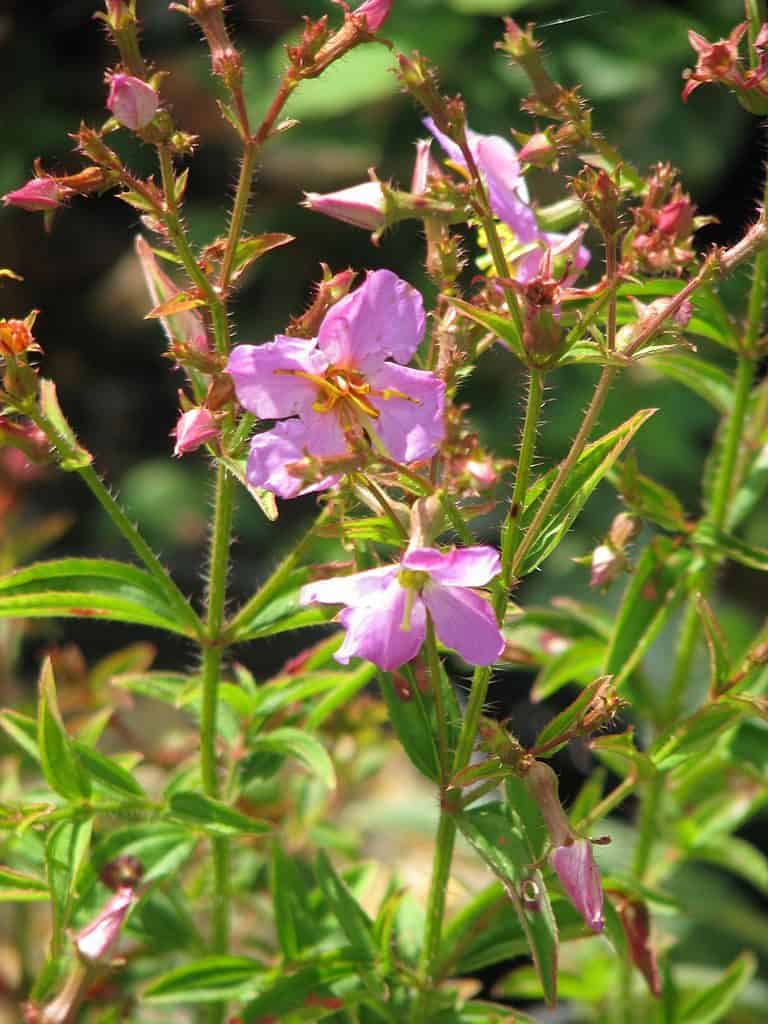
The sandy or gravely shorelines of some of the lakes have relic plant species that have persisted here for 10,000 years. These rare sites are known as Atlantic Coastal Plain Communities. The vegetation spread to this area from the coast of the eastern U.S. during the melting of the last ice sheet. These plants have adapted to fluctuating water levels. Many are provincially rare, including Bayonet Rush, Twin-scaped Bladderwort, Yellow-eyed Grass and Virginia Meadow-beauty. The latter flowers in late summer and sets shorelines aglow in purples and auburns. You can see these communities yourself by visiting Bottle Lake in Kawartha Highlands Provincial Park, north of Peterborough.
Wetlands
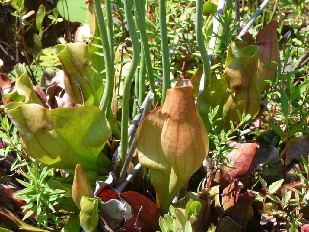
Marshes, swamps, fens and bogs – collectively known as wetlands – are another signature habitat. Many are situated between the rocky ridges and are largely the result of beaver dams. Wetlands contain water-loving plants and organic sponge-like soils, which work together to filter water and regulate water levels. Two of the most interesting wetland varieties in The Land Between are bogs and fens. Bogs are acidic wetlands that are low in minerals. They accumulate peat, a deposit of dead plant material mostly made up of sphagnum mosses. Many are located along shorelines. Rooted in the moss are carnivorous plants such as Pitcher Plant and Round-leaved Sundew as well as a wide variety of orchids. Crane Lake Kawartha Highlands Provincial Park and Quiet Lake in Silent Lake Provincial Park have excellent bogs.
Fens are very similar to bogs in that they contain large peat lands. However, they are dominated by grasses and sedges. Fens often receive water and nutrients from a water table that is close to the surface and keeps the ground saturated. The Sharpe Bay Fen Conservation Reserve is an excellent example of this habitat type. It is located about 50 km north of Peterborough on the east side of Highway 28, just south of Long Lake Road. The area is interspersed with rock ridges and contains fen forests. It provides known habitat for the Five-lined Skink.
Alvars
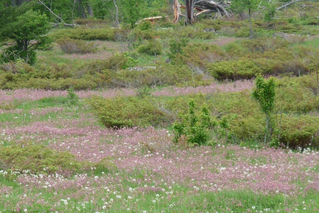
Alvars are another rare habitat in The Land Between. The word describes an area of thin or absent soil cover on top of a limestone base. The sparse but distinctive vegetation may include shrub-dominated areas of junipers and hawthorns, more open tracts of grasses and wildflowers, or just flat expanses of lichen and moss encrusted rock. Large trees are either absent or widely scattered. A nearby alvar grassland is located approximately 500 m north of Flynn’s Corners, along the east side of County Road 507, north of Buckhorn.
Ontario’s new Carden Alvar Provincial Park, however, is the best example of this kind of habitat. It is located northwest of Lindsay, just north of the town of Kirkfield. The Carden Alvar is the best place in Ontario to see large numbers of grassland and scrubland birds, especially along Wylie Road. Like a remnant of old rural Ontario, you can easily find iconic species such as Eastern Bluebirds, Bobolinks, Eastern Towhees and Sedge Wrens. At night, the calls of Whip-poor-wills and Common Nighthawks ring out. The Carden Alvar is Ontario’s last remaining stronghold of the endangered Loggerhead Shrike. The scenic gravel roads are also rich in butterflies – over 80 species – and dragonflies.
Alvars are a botanist’s delight. Many of the wildflowers and native grasses found here normally occur in the western provinces, and many are rare. The signature plant at Carden is the Prairie Smoke, also known as Long-plumed Purple Avens. Large drifts of its mauve seed heads stand out smoke-like against the green grasses. Other interesting plants include Wood Lily, Indian Paintbrush, Hairy Beard-tongue, Fragrant Sumac, Balsam Ragwort and Little Bluestem.
Barrens and Forests
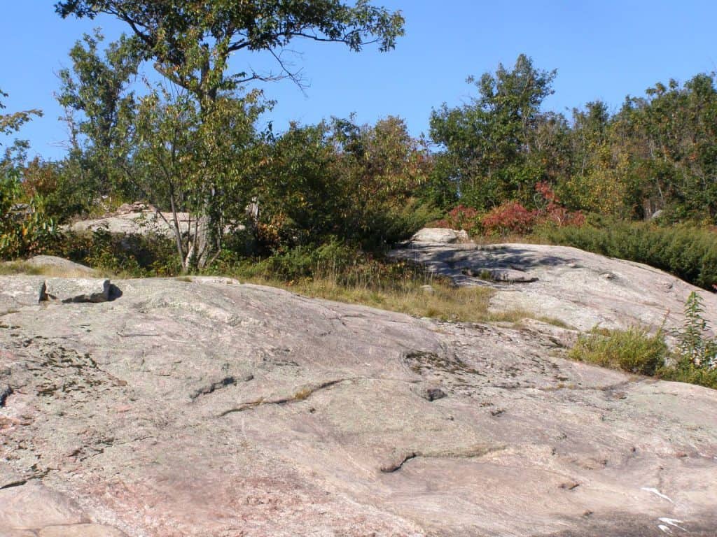
Areas of exposed granite and gneissic bedrock are one of the most striking features of The Land Between. As with alvars, the soil is very thin and supports early succession species like lichens and mosses. Scattered here and there, you can also find grasses, junipers, hawthorns, oaks and poplars. Rock barrens are perfect basking spots reptiles like snakes and Five-lined Skinks. Other species associated with these habitats include the Whip-poor-will and the Common Nighthawk. An area of outstanding rock barrens is located immediately north of Long Lake in Kawartha Highlands Provincial Park.
As is immediately apparent on satellite maps, much of The Land Between is heavily forested. Relatively mature forests dominated by White Pine are scattered throughout the area, as are forests where Eastern Hemlock, Sugar Maple and Red Oak prevail. Large tracts of forested landscape are requisite habitat for Moose, American Marten, Barred Owls and Red-shouldered Hawks. All of these forest types can be found in Kawartha Highlands Provincial Park.
Next week I will look at the pressures faced by The Land Between, the many conservation initiatives that are taking place and the excellent work being done by The Land Between National Charity.

